Directions to the Lilburn cabin site
This is a description of how to get to the old cabin site at Lilburn. All coordinates are in UTM, WGS84 datum.
For a general description of caving at Lilburn and what to bring, click here.
1. From the Bay Area or Northern California, drive to Fresno and take Highway 180 East.
• From Southern California, on Highway 99 take exit 106-B through Traver, towards Dinuba, and then to 180. It’s easier with a GPS, you can set it for this address in Yokuts Valley: 30894 East Kings Canyon Road, Yokuts Valley, CA 93675, just as a dummy address to take you to 180. Why the dummy address? Because if you just put the coordinates for the trailhead it’ll send you through Visalia and the Generals Highway, which takes longer. Or you could just get to Fresno and take 180 East. It’s only slightly longer than through Dinuba.
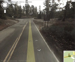
2. You’ll see the park booths welcoming your money (don’t worry, you don’t have to pay since you are on a research trip, just let them know that you are with the Cave Research Foundation, going to Lilburn Cave in Redwood Canyon, and show them your copy of page 1 of the research permit), and once inside you’ll get to the intersection of highways 180 and 198. Take a right onto 198, towards Visalia (Lodgepole / Sherman Tree / Hume Lake).
3. After 3.6 miles you’ll get to Quail Flat (11 S 0329490, 4065686). In winter trips, this is often as far as you can drive, and you’ll have to hike from here. In a winter trip, park in the big area where the toilets are. There are no bear boxes, so plan accordingly. For the rest of the year, you can drive for a little bit more.
4. From this point you’ll leave the paved road and take a dirt road. It’s usually not a problem for 2WD cars to get to the trailhead at Redwood Saddle (11 S 0328417, 4064156). If you are hiking, it’s 2 miles downhill.
5. Don’t leave food, toiletries or anything smelly in the car, use the bear boxes at the trailhead. Take the Hart Tree / Redwood Canyon trail.
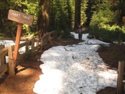
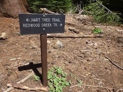
6. It’s five miles, normally about two hours from here to the cabin. Go down the trail, and soon you’ll reach the Redwood Creek Trail junction (11 S 0328550, 4064416). Take a right and keep going down into the canyon.
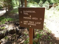
7. Follow the trail, past a muddy spot (“Memorial Spring”, 11 S 0328837, 4063754) and three fallen sequoias, and it will eventually take to you another junction, with the Sugarbowl Trail Junction (11 S 0329331, 4062373). Keep going straight, towards “Hart Tree Loop / Big Springs.” You’ll walk next to the creek for a little bit.
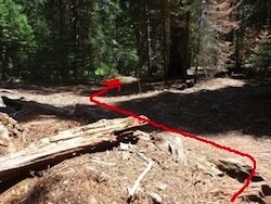
8. The next junction is with the Fallen Goliath and Hart Tree Trails (11 S 0329370, 4062165). Keep walking more or less straight along the bottom of the canyon (the trail makes a small “S” at the junction: take a left immediately after walking on top of some rotting wood, then take a right just past the sign. The trail keeps going along the bottom of the canyon, but there is no sign pointing to Big Springs).
9. You’ll reach the creek crossing (11 S 0329417, 4061880). The trail gets down towards the creek and then takes a slight right turn, into a wide sandy area. Most of the year you can step on rocks to cross, but in high flow it’s better to take the boots off and just walk along the bottom (some people bring neoprene socks or sandals for this).
10. From here on, just follow the trail (it leaves straight uphill from the crossing), there are no more junctions. You can skip the rest of the explanation, and just use the cabin’s coordinates (11 S 0329508, 4059272) for reference. The trail does some twisting, so don’t worry if at times it seems that it’s not taking the most direct route.
The next steps describe what happens between the crossing and the cabin, in case navigation is not easy (for example, for winter trips when the ground is covered in snow):
11. In winter, this part of the trail after the crossing is confusing because the trail doesn’t follow the bottom of the canyon, but the landmarks are:
• Sequoia (11 S 0329682, 4061646). The trail stops climbing for a little bit and goes behind of the sequoia and to the right.
• Walking above the root of a fallen sequoia (11 S 0329799, 4061561). The trail again stops climbing for a little bit and takes a right.
• Another sequoia (11 S 0329813, 4061501). The sequoia is to the right of the trail.
• Volvo Creek (11 S 0329865, 4061457). A small creek crossing. There is a narrow spot a little bit upstream that makes crossing much easier.
• Yet another sequoia (11 S 0329871, 4061386). The sequoia is to the right of the trail.
12. The Black Stump (11 S 0329857, 4061082), a blackened tree stump, is more or less the end of the uphill section after the crossing, and roughly a third of the way to the cabin from the crossing.
13. At this spot along a fallen tree (11 S 0329871, 4060913) the trail makes a hard right and goes downhill, which with snow on the ground is not very obvious.
14. “Surprise Log” (11 S 0329495, 4060918) is basically the bottom of the downclimb from the "spot along a fallen tree" landmark. The trail gets back to the lower section of the canyon and takes a left.
15. There is a small blowing hole (11 S 0329403, 4060546) that in winter has no snow around it.
16. At Contact Falls (11 S 0329328, 4060384) you may be able to hear water flowing on your right, or maybe even see the falls.
17. Cedar Cave is the next landmark, the entrance will be to the left of the trail.
18. And finally, the cabin site (11 S 0329508, 4059272), to your left, slightly uphill. Success!